zendumaps, gofleet, gis, mapping, winter maintenance, waste management, city works

6 Industries that can benefit from ZenduMaps

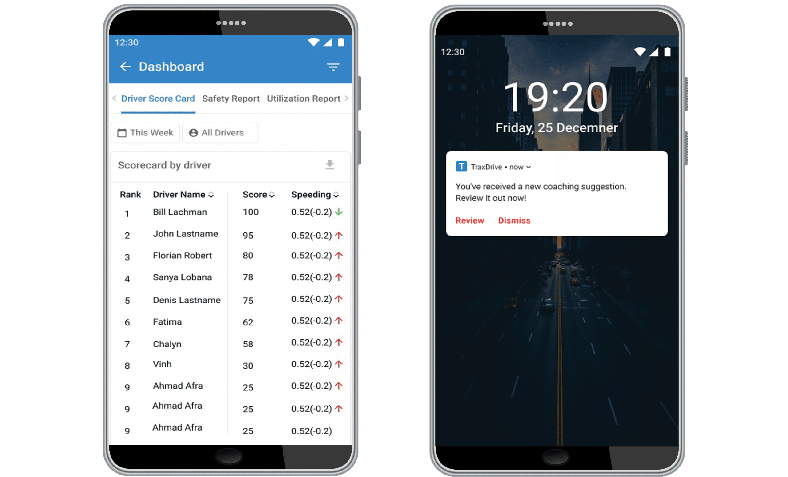
By now, you’re familiar with the ZenduIT mapping software system that we offer ZenduMaps, which offers real-time location-based operations management that benefits fleets across a number of industries. The use of telematics is becoming increasingly prevalent among fleets, and managers of all kinds are beginning to understand the benefits of tracking vehicle location, driver behavior, work planning and so much more.


While the more obvious applications for ZenduMaps might include winter maintenance and seasonal road work (read more about the advantages of ZenduMaps for public works here), there are a number of operations that could benefit from this powerful fleet management tool. 


City Planning


Geographic Information Systems (GIS) have been very successful tools for urban and rural planning over the last several years. Whether the task is planning for new roads, working out local taxes or planning the next desirable neighborhood, the data gathered from ZenduMaps can help develop a new city, track its expansion and plan the direction of future growth.


Using GIS data, cities can manage planning, analysis and reporting — all factors that are necessary for successful building. With this secure, cloud-based software, stakeholders across local government and private organizations can be engaged to ensure that zoning, city bounds, street names and more are accurately and efficiently mapped. The platform provides geospatial data sets that deliver more effective solutions for planning management and city operations. 


Waste Management


The ZenduMaps platform has integrated tools to help improve productivity and reduce costs, both of which address common challenges within public works, but can be applied specifically to waste management. The public sector has a unique set of needs; waste collectors have the double task of clearing garbage quickly, efficiently and on a regular cadence, while appeasing constituents . 

ZenduMaps can manage and optimize waste collection vehicles, increase productivity and encourage fleet managers to adhere to waste collection schedules. The routing function increases fleet visibility and efficiency, while optimizing pickup schedules and litter control. Moreover, scheduled pickups and routes are searchable and viewable by the public, which fosters goodwill and keeps citizens informed.


Government


Government contracts represent some of the biggest use cases for ZenduMaps, as well as some of the greatest accountabilities. In this instance, GIS data can track all vehicles, assets and routes on a live map, allowing you to receive alerts based on predetermined triggers. The platform can also produce maintenance schedules and reports to reduce fuel costs and maintain vehicles before a problem arises.


The mapping of service locations and routes offers real-time feedback on completion rates and allows government agencies to proactively detect missed services or insufficient resources before they become a problem. 


To help manage public perception, the public can gain visibility into historical reporting and analytics for service verification, including work location with date and time stamps. By benchmarking the capacity of staff and equipment, an agency can verify the need for additional resources, or reallocate existing resources to other projects.  


Transportation


GIS data is commonly used for managing existing transportation issues while allowing those agencies to plan ahead for new roads and routes. The ZenduMaps solution offers fleet managers full visibility into the operational data of all government vehicles on a single platform, and provides the tools to effectively reduce costs, maintain compliance and ensure road safety.


Water Utility


One of the most critical areas for geospatial technology is water asset management. Mapping solutions provide water utilities with improved asset management capabilities. Creating smart, connected networks with water utilities can ensure clean drinking water for a community, a city, or the global population. In this case, agencies can accurately and efficiently maintain the utility’s infrastructure to help meet the increasing demand for water.


In addition to tracking water pressure and monitoring potential leaks, GIS mapping technology plays a vital role in digitizing water networks, and can help provide valuable insights into locations and assets, including pipes and reservoirs. Data gathering, both historical and current, can help water utilities plan new infrastructure projects and provide a complete picture of the utility’s performance. Water managers can use this technology to improve service levels and ultimately improve customer satisfaction. 


Agriculture


Pursuant to the development of water utility infrastructure in cities, GIS data also holds sway in rural areas where water is essential to the agricultural industry. The availability of water directly affects crop production in a given region; GIS mapping can produce efficient techniques for farming, identifying crops and determining yield. GIS data can also help analyze soil data, which increases food production.


The goal of a mapping platform is to reduce costs while improving efficiency, operational effectiveness and quality of service. Speak with one of our consultants about implementing a solution for your industry. Contact us now for your free trial!

cityworks, mapping, zenduit, zendumaps, gofleet, government, fleet

A Beginners Guide To Cityworks And Its Benefits

In the latest integration of systems that improve workflow and increase transparency among its stakeholders, ZenduIT has merged processes with Cityworks technology to create a veritable mapping superpower, aimed at engaging not only city workers, but regular citizens as well. By leveraging geographical information systems (GIS), Cityworks uses data to connect previously siloed city systems and ultimately build safer, smarter and more resilient communities.


What is Cityworks?


A geographic information system creates, analyzes, maps and manages all kinds of data; it connects data to a map, integrating “where things are” with descriptive information, such as “what things are like there”. It helps us understand patterns, relationships and the context within a geographical location. GIS creates fertile ground for mapping and analysis that can be used in virtually every industry, improving communication, efficiency, management and optimal decision making. 


Cityworks helps you fully use your GIS data and improve operational efficiency. This leading web-based GIS asset management system tracks, manages, scores and analyzes the assets that comprise your infrastructure. Designed to help city-run agencies streamline their workflows, track data and improve communication, Cityworks helps local governments and utility agencies get work done.


Scheduling work activities


Cityworks provides a detailed foundation of asset management. Cityworks allows you to combine assets based on key factors such as age, type and location. These groups can be used to create and schedule various maintenance activities.


Mapping Tools


Because Cityworks is built exclusively on GIS, you can easily map open service requests, or work orders of varying types. These tools empower and encourage you and your staff to use asset data and create an integral part of the work management process.


Mobile Data


We live and work in a mobile-centric environment. Your data should be portable as well. Cityworks has a number of tools to help your crew access and update valuable content on site and on the go.


Work Orders


You can track work that has been performed on an asset at any time throughout its entire lifecycle with Cityworks. Users can search for work orders and view them on the GIS map. Track active or overdue work orders and monitor work, regardless of whether it’s associated with a specific project, contractor or task.


Improve Communication


Once you can track asset data and work history, you can better share this information with staff, cross-functional departments, and public citizens. Cityworks users have created solutions to improve communications across a number of tasks, including repairs, inspections, emergencies, permits and resident requests or inquiries. 


How Cityworks can benefit your city


Fostering goodwill


Often, information silos and archaic systems prevent a city’s infrastructure from working efficiently. ZenduIT works synergistically with Cityworks to improve communication between a city and its constituents. Imagine having a work management tool that creates digital public maps where citizens can report issues in real-time. 


ZenduIT’s mapping interface, ZenduMaps, allows the public to do exactly that. No more long, laborious 3-1-1 calls. Whether there’s a spotted pothole or burst pipe, users can simply click on the digital map and feed that data to the proper department. When they’re shared, intelligent monitoring tools foster goodwill between a city’s inhabitants and the infrastructure that’s there to support them.


Automated processes and applications


Connecting technology offers better tools to communicate with the residents within a city. For example, Cityworks can streamline the process of tracking property stabilization by making data and inspection status easily accessible and transparent across departments. This system of record keeps both residents and city employees in the loop and fosters efficient workflows.


Similarly, ZenduMaps can create a public map, whereby residents can report issues or render complaints in real-time, either on the site or using their mobile devices. Issues are submitted to the proper city department, and the tool can now allocate work to the proper crew, or feed into a third party work order management system such as Cityworks. Consider the applications for not only road work, but waste management and winter maintenance. Most cities currently operate under a “search and fix” process, but with strong citizen engagement and specific GIS data, the continuous course of mapping and fixing can create proactive, predictive patterns for future work, patrolling and route optimization.


Cityworks and ZenduMaps work together to drive public engagement; that component of citizen involvement helps create a dynamic and transparent workflow, where everything from reporting issues to taxes can be managed interchangeably, with input from the people who are most impacted.


Work management tools save time and generate efficiencies. When they’re connected, these same tools can also create goodwill within a community and improve some of the city processes currently in place. Together with ZenduMaps, Cityworks will help you build safe, resilient and smarter communities.

zenduone, gofleet, mobile, app, zenduit, zenducam

ZenduONE Can Grow Your Business — Here’s How.

In a recent webinar we launched and shared information about the ZenduONE Mobile App and how it can be leveraged by fleets to streamline performance. To briefly recap, ZenduONE is the latest evolution of our streamlined performance and end-to-end business solutions. Users who download the mobile app from iOS or PlayStore can access all of the digital business solutions while on the move — in just a few clicks.  This comprehensive dispatch, operations and accounting system enables fleet managers to leverage their existing dash cams to review video footage on the go. 

ZenduONE is, above all, part of a group of scalable service offerings that can grow and adapt to your ever-changing business needs. Now, more than ever, you can get the content you need, without scouring hours of footage or reviewing irrelevant alerts.


Scale up or scale down


With ZenduONE, you can access all of your solutions from a single app. The goal of the app is twofold: providing visibility to drivers into their performance on the road in real-time, and becoming a convenient tool for fleet managers to expand their fleet business while gaining valuable insight into fleet productivity, operations and safety.


All of your favourite ZenduIT apps can now be accessed on the ZenduONE platform: Asset, Video review, TimeCard, ZenduMaintenance, ZenduReports, and so much more. A range of 15 fleet applications are currently available to install with a single click — and more on the horizon. You can rest easy knowing that all of your users will be fully supported.


ZenduIT has modularized the ZenduCAM platform into separate entities in order to host them all on one app and more importantly, keep your productivity organized based on the functionalities that matter to you.


What does this mean for your business? ZenduONE accommodates your shifting priorities and organizational needs. If you’re a fleet manager, you can review video footage based on the alerts you’ve predetermined, process a work order for vehicle parts, dispatch a driver, review time cards, or find asset locations on a map; and you don’t ever have to be at your desk. Whether you have a large fleet or are just starting out, ZenduONE allows you to pick and choose the workflows you need, when you need them.


Interested in learning more about how ZenduONE can provide a fully-integrated, scalable workflow experience? Schedule a demonstration with one of our consultants and try us for three months — absolutely free!

GoFleet Offers Vehicle Dash Cam Solutions Across A Number Of Industries

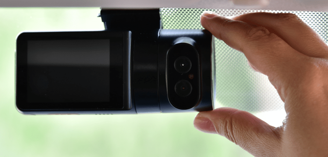
Generally speaking, commercial dash cams are well-suited to answering “when” and “where” questions around accidents or other incidents involving your vehicles. When paired with a top-tier telematics platform, your dash cam system can provide a deeper dive, answering the “why’s” and “how’s” of driving behaviour on the road. Dash cams ensure and improve safety for drivers and vehicles, while providing peace of mind to the people who employ them. 


By now, you’re likely familiar with GoFleet’s dash cam offerings. What might be less familiar is which scalable, comprehensive solution will work best for your fleet. Depending on your requirements and the industry in which you operate, the answer can get complicated.


Whether you have a handful of vehicles, or an entire cavalcade, both our dual-facing and multi-camera options help correct similar issues across nearly every fleet industry. “From my experience, it’s not about fleet size. For example, a client might want a four-channel setup, because they want a camera solution that has a nearly 360 degree view to get a better understanding of who’s at fault,” says Ron Sabbun, who works with Strategic Partnerships at GoFleet’s Partner ZenduIT. “Our product sales depend on two main criteria; customer requirements, and the industry they’re in.”


With a number of device solutions, paired with a robust Trax platform that can monitor vehicles, report on and interpret driving data in real time, the applications for commercial dash cams seem nearly limitless. In this post, we’ll look at some of the more universal use cases for commercial dash cams that GoFleet can solve for. 


Driver Exoneration


Whether you work in transportation, waste management, hospitals, government, field services or passenger transport, a time may come when your driver is involved in a traffic accident.


“One of the major reasons customers elect to get dash cams is to get video evidence of any incidents that occur while their driver is on the road,” says Sabbun. “In an accident, they want to get a better idea of what led up to the event, the driver’s reaction during the event, and who was at fault.”


Not coincidentally, Sabbun points to passenger transport as a growing industry that requires the use of dash cams. Unlike public transportation, passenger transport describes the privatized movement of passengers on a given network, such as transporting people with special needs, or ferrying executives around. “These companies really understand the liability process if their drivers get into an accident. Not only does the driver have to prove that they were not at fault, but they require evidence that their passengers weren’t injured.”


Preventing Distracted Driving


While issues of fatigue or driver drowsiness tend to be risks associated with trucking, distracted driving can affect any driver in any industry where vehicles are employed. Dual camera systems with both driver and road-facing camera views would be a popular choice where it’s a requirement to monitor and gauge a driver’s behaviour inside the cab, especially as that behaviour relates to an accident. GoFleet’s cameras offer advanced alerts for fatigue and driver distraction, which focus on a driver’s physical indicators, such as his facial features and the direction of his gaze. For added safety, the camera will produce an audible alert in the event of distraction; a great tool to keep your driver’s eyes on the road where they belong.


Content Review


Commercial dash cams display video relating to an event of interest for the purpose of review. Events of interest can either be an on-demand request that has been flagged by a fleet manager, or automatically triggered by a preset list of notifications. Either way, a fleet manager’s time, the number of events or notifications, and the number of vehicles sending data back to the business are all factors that can contribute to a bottleneck in the review process. Having the right tools to sort through the most critical events for review is essential. The content review process can even be simplified by GoFleet’s Managed Services, which allows fleets to work with industry consultants who provide recommendations on how to increase safety and sort through dash camera footage for you.


Generating Reports


Dash cams can generate a lot of data within a very short time frame. Distilling that information into key metrics that measure how drivers and fleets are performing over time is essential to fleets big and small. GoFleet’s telematics system will provide reports such as driver scorecards, which help measure how a driver is performing over time, as well as how he compares against his fellow drivers. Scorecards can provide the foundation for both reward incentives and coaching programs. 


Providing Feedback


Coaching and feedback between drivers and fleet managers create value and can provide a significant ROI. Depending on the size of your business, you can initiate a review and/or coaching session based on metric-driven reports, either in-person or by supplying drivers with a formal review checklist. This list compiles shortlisted events and videos, as well as notes and comments; completion of a pending review can be part of a driver’s to-do list before starting the next trip. 


Opportunity for feedback ensures that our solutions make your job easier, while improving workflow and increasing overall fleet safety. Reporting and feedback are scalable solutions that can work in virtually any industry that employs a commercial fleet.


Reducing Operational Expenses


Your fleet can realize major savings by implementing commercial fleet dash cams. Outside of exonerating drivers, there are significant savings around fewer traffic violations, reduced insurance premiums and lower maintenance costs for your vehicles. There are also a number of studies that illustrate a correlation between safe driving and better fuel efficiency (examples here, here and here).


Driver Retention


There has long been an impression of dash cams as a means to surveil drivers. While the primary purpose may be recording and monitoring driving behaviour, the process of reviewing content doesn’t have to be punitive. Rather, dash cam telematics can create recognition programs within your fleet, in addition to capturing accidents. In fact, driver scoring encourages your fleet to maintain positive behaviour and create a work culture based on compliance and safety, a key factor to driving engagement within your team.


Conclusion


From a growing awareness of the value of commercial dash cams to the availability of cutting-edge hardware with a host of functionalities aimed at keeping drivers and vehicles safe, dash cams are now the norm for commercial vehicles and fleets of all sizes. As the choices keep expanding, so does the analysis process. Selecting the right dash cam solution requires you to look at the combination of hardware and software holistically, within the framework of your fleet’s requirements. Thankfully, GoFleet is here to assist you with navigating your decision-making journey.


Schedule a demonstration and get a FREE trial when you contact your GoFleet consultant. There’s never been a better time, call now!