Precision Farming: How Technology Can Improve Efforts

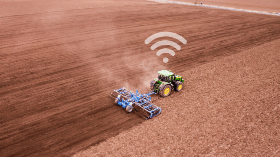
Even though many still envision farming to be very labor intensive, it’s important to highlight how this has changed. Specifically how the agriculture sector has been adopting innovative technologies that pair with heavy machinery to boost efficiencies. And as a result, allowed for time-specific operations to be met regardless of changing variables. Below we discuss how telematics and precision farming is the new normal for countless agribusinesses within the agricultural and agri-food chain.


Telematics And Precision Farming: What Is The Relationship  


As briefly mentioned, telematics continues to find new and impressive uses. When speaking to agriculture, the implementation of telematics began in the early 1990s. This was largely due to GPS guidance being used by tractors. Since then, a lot has changed in terms of the advancements. Specifically the increase of precision through the combination of methodology and technology. Or, otherwise known as precision agronomics and precision agriculture which boosts the accuracy of farming techniques when it comes to planting or growing crops. 


Precision agriculture happens by collecting information via sensors or devices which then uses cellular and satellite connections to transmit the data to varying locations. Typically this information is sent to the cloud to be stored as well as other devices where software solutions are able to utilize the data. All of which allows users to go in at a later date to view and make appropriate changes. 


Such adoption of sensors, trackers and other tech-tools in agriculture operations have allowed for a unique ecosystem to be formed. This is not only visible in personal operations where the data, tools and actions work hand-in-hand, but in the agricultural sector as a whole because findings or techniques are often made public. With this being said, there is a lot of opportunity for tech-driven agriculture to grow, with many predicting for even more growth to happen in the upcoming years. In fact, it is expected for precision farming to increase from being a market worth USD 7.0 billion to USD 12.8 billion by 2025, at a CAGR of 12.7%. 


Where The Original Need Comes From


As one can imagine, farming and agriculture work can be extremely labor intensive. Meaning, tools that can reduce the physical strain (and double as tools that make it more efficient) couldn’t be overlooked once suggested. When speaking to agriculture, it was found that telematics technology could be implemented into everyday practices to help move processes along and reduce errors that lead to wasted resources. Ultimately allowing for more work to be completed in a shorter time frame with less waste of seed, fertilizer, fuel and time as new precision was found. 


Precision Farming 


As mentioned before, precise farming or otherwise known as precision agronomics speaks to combining methodology with technology. Meaning farming techniques are adjusted to allow for more precise planting and crop growing. 


There are four tools and/or techniques to highlight which include; variable rate technology (VRT), GPS soil sampling, computer-based applications and remote sensing technology. 


Variable Rate Technology 


Variable rate technology refers to the ability of farmers placing specific controls on certain locations. Specifically changing the amount of inputs they apply. VTR focuses on using software, controllers, as well as differential global position systems (DGPS) to adjust their efforts. 


This technology is useful to ensure that resources are not wasted. When seeds are planted and incorrect paths are used while planting the seeds, it could cause too many to be distributed in one location (as a result of overlap passes), causing for growth to be limited. With VTR, controls can be used after environmental data is analyzed to ensure that seeds are planted appropriately. 


GPS Soil Sampling


GPS soil sampling refers to the testing of the soil in a specific location. Focusing on the available nutrients, pH levels, and other information that can affect how well a crop may grow. Understanding this is critical because without this information, individuals planting crops may not understand how they could have a more successful season. Sometimes it can be as simple as gathering data from the soil, analyzing the information, and applying certain precautions. Such precautions could be as simple as distributing fertilizer because the soil is naturally lacking some nutrients. 


Computer-Based Applications


Computer-based applications are highlighted for their abilities to create various plans and maps including farm plans, field maps, crop scouting and yield maps. These applications allow for precise actions to happen in regards to application of inputs (pesticide, herbicides, fertilizers, etc) on a visual and geo-specific level. Resulting in knowledge of the ground level, type of soil, among other environmental aspects to be known so more direct actions can take place. 


These applications can allow farmers to better understand the environment where they are going to be planting. As the leveling of the ground, type of soil and other information that farm plans, field maps, crop scouting and yield maps hold may require farmers to take extra precautions when planting. Telematics implementation via computer-based applications pull all of this and display it for farmers to better understand pre-planting needs. 


Remote Sensing Technology 


Remote sensing technology is exactly as one may expect – sensor technology that can remotely monitor and manage certain efforts. For agriculture, this can be seen at times when there are certain stressors affecting the quality of the crop such as hot temperatures eliminating moisture from soil. Sensors can be used to monitor all of this and alert farmers of certain conditions that may be harmful. When discussing the example of hot temperatures eliminating moisture from soil, sensors can detect when the soil has reached a specific level of dryness, prompting teams to add additional water. Forgoing alerts from sensors means that teams will have to physically monitor and estimate not only when to make changes but how much change should be made. 


Additional Benefits Come From Telematics In Farming


Depending on the work being performed, some farming operations may find certain telematics solutions more useful than others. Since high demands, changing environmental conditions, and fluctuating weather patterns can all affect the agri-industry, there is an ever-evolving need to adapt. For farming and agriculture, the solution is technology and tools to allow for precision farming. 


While the purpose of the technology can vary, the benefits that arise are typically the same. Usually, the telematic solution will increase efficiency, boost resource utilization, improve monitoring of efforts, aid security and increase maintenance management, among others. These benefits are further discussed below. 


Increased Efficiency And Resource Utilization 


As previously mentioned, telematics solutions can be extremely beneficial within the farming sector as it allows for operational efficiency. For example, one tool that has not been discussed yet, GPS tracking technology, can be leveraged to increase efficiency and resource utilization. This is because GPS tracking can allow for teams to monitor where equipment is or has been throughout the day. In fact GPS tracking or other high precision positioning technology has been adopted in nearly 80-90% of the tractors in the Western world. Tracking this data and mapping it ensures that the planting of seeds is precise and there is no overlap passing as previously mentioned. Ensuring that the right quantity of seeds are planted to lower wasted resources and reduce overlap of paths to reduce wasted fuel. 


Virtual Monitoring And Optimized Efforts 


In addition to boosting efficiency and resource utilization, telematics helps to monitor conditions to optimize efforts. As briefly mentioned, knowing specific information about crops and environmental factors can drastically affect the outcome of the crop. For example, a crop that has soil that is too moist or too dry could be difficult to notice unless someone is walking through fields or crops and checking on the conditions. However, with telematics, devices can be implemented to gauge what the conditions are like in specific geofence locations – so if one portion seems to be too dry, teams can optimize their efforts and rewater as necessary. 


Security 


As telematics focus on tracking the GPS location of assets, many are finding that telematics can act as a security tool. When GPS location tracking information is displayed on a visual map, teams can know where equipment and heavy machinery is located – and in some cases, see the ‘last known location’ if the asset is no longer on the map. Using telematics tools to track location helps during the recovery process if assets go missing as the last known location and even in some cases the current location can be tracked. 


In addition, geofences can be used and set up to alert teams when an asset is removed from a pre-set zone. All of these features result in theft of heavy machinery (which can be costly to replace) to be reduced, as well, for missing equipment to be found sooner so replacement costs are avoided and perpetrators are prosecuted. 


Maintenance And Troubleshooting From A Distance 


With telematics technology installed, heavy machinery and equipment can have their health status monitored. Specifically as telematics can not only record how the asset is being used, but the data can be inputted into software solutions and applied to algorithms to determine how the asset is performing. In many cases focusing on the efficiency of the vehicles (fuel usage and idling) or preventative maintenance scheduling. Preventative maintenance is a major benefit to highlight as using telematics and IoT connectivity can help to reduce the likelihood of unexpected breakdowns that halt work as well as the need to bring heavy and large equipment to be serviced unexpectedly. When this is not prepared for, owners of the machines risk high costs related to transporting the equipment, conducting repairs and even lost time. Using telematics for preventative maintenance has been known to reduce repair costs by up to 25% if performed regularly. 


How GoFleet Is Helping


Above are only a few of the general benefits that companies within the agricultural and farming sector have noticed after implementing telematics. While these benefits and the extent of improvements differ from business to business, speaking to a solutions provider about your specific needs and industry can help. With our experience, we’re confident that our team can take your unique needs and find a solution that allows you to see measurable results. 


John Deere Program 


One available solution to highlight, is part of the OEM (original equipment manufacturer) program via the Geotab integrated solution for John Deere. The telematics solution works to provide more information through a number of agriculture-related equipment to boost reporting, monitoring and machine operations.